
Perth Slalom training camp – Charlie’s Video
Posted by robjwall on August 19, 2014
Posted in Uncategorized | Leave a Comment »
Kalbarri National Park draft management plan 2014 Public Comment Submission
Posted by robjwall on July 22, 2014
The Dept of Parks and Wildlife is seeking comment on a plan for the KalbarriNational Park. By 20 June 2014.
This is the plan. http://www.dpaw.wa.gov.au/images/documents/parks/management-plans/KalbarriNationalPark_DraftPlan2014_WEB.PDF
It does not prohibit climbing. But it does not plan for it in any way. It also does not allow camping in the park, nor allow for vehicle access to climbing areas(eg 4-ways track will only be for commercial use).
The link is the submission I made on behalf of “W.A. Rock Climbers concerned with the Kalbarri National Park”
KNP download.
Posted in Uncategorized | 1 Comment »
Lunch on the trail near Pemberton WA
Posted by robjwall on May 27, 2014

Posted in Uncategorized | Tagged: bike | Leave a Comment »
Esperence Sea Kayak
Posted by robjwall on January 23, 2014
17 – 23 January 2014.

Remote Rocky Islands – Strong Winds – The Southern Ocean – Three Men – Sounds like an epic doesn’t it? Actually it was a remarkably straightforward and beautiful trip.
We left Freo on Friday, and after a delay while Rob welded my trailer rack after Bryan broke it, were on the road. We arrived late and crashed at the launch site at Lucky Bay (leading to the predictably grumpy ranger the next morning. After way too long putting things in and out of dry bags, we paddled off at 10am around to Thistle Cove for morning tea. (Taking in the sights of the by now famous Kangaroo Rock climbing area :)). Then it was time for a long fast downwinder around past Cape Legrande itself (it looks to me like there would be some ok Trad Climbing here) to an unnamed cove. It was hot and windy so I wasted a lot of time putting up a tarp using lots of tension to stop it flapping, and paddles as supports. Then the paddle broke! We had been wondering if we should take one or two spare paddles and chose one (bad decision).
We all slept well until the 5am Mosquito alarm clock, and were back on the water about 930 for the 11k crossing to the island “Sandy Hook”. I am paddling a Mirage 530, lent to me by Yvonne (Rob’s Wife), its nice to paddle despite my overloading. Bryan is in my Lettman Speedliner (impossible to overload), and Rob has a borrowed plastic sea kayak (would be slow but he has a sail!). The crossing was long but pretty quick being almost downwind again. We spent a nice afternoon listening to Kelp Gull, and took a short walk up to the Ridge before sunset. We are on the one beach on the island (pictured) which is the most beatifual place to hang out and contemplate nothing much.
In the (monday) morning we left at 9am and paddled around the West side of the Island which was out of the wind, and had some great rock formations to look at. (No picture – you will have to go there yourself :)). We landed at one point because I didn’t want to pee in the boat! This proved to be difficult, even in calm sea… Then we had some quite difficult cross wind paddling through a gap, and on to “Woody Island” where we got an actual bed, and all slept for a couple of hours. For an evening walk I went over the main hill and then rock hopped / bush backed back to base (hard). The permanent camp on the island is looking very run-down which is a shame as its a great spot and deserves to be a popular “Eco-resort”.
On tuesday we got up at 6.15am and got a scheduled forecast on Marine VHF 72 (this was the only time we used the radios, I’m not sure we could actually have reached anyone) which was not good. The wind strength was forecast to pick up to 40 Knots by lunchtime which could make our craft uncontrollable, so we decided to take the less risky option and paddle 17k downwind to Esperence town, not 10k upwind back to the bike we had left on the shore as planned. This was a long but uneventful trip – my mid-morning pee was accomplished by climbing out of my boat in the middle of the sea to the amusement of the other guys. My back was sore by the end of this day (perhaps because this is the day we did NOT do yoga?). The taxi back to our car was $230 – Ouch. The kids texted me and are having fun at the National Whitewater champs at Penrith!
On the final day I abseiled down some climbs I want to do at Kangaroo Rock, but the wind was 30 Knots, so I gave up looking, and went for a walk up Frenchman’s Cap instead with Rob and Bryan.
Lessons. Water bags are better than bottles. Take fewer smaller dry bags. Take more spare paddles. Take printed Satellite photos (these are better than charts for finding beaches to land on). Make sure your charts cover enough that you can see Islands in the distance as well as close ones as they make very useful landmarks when navigating (my compass broke, and I don’t trust the one on my watch).
Posted in Uncategorized | Leave a Comment »
Cape to Cape
Posted by robjwall on October 28, 2013

Is the name of a bushwalk (which I have to complete one day too…) but more recently a popular mountain bike race in SW WA. I picked it as this years ‘hard’ challenge, and was not disappointed.
http://capetocapemtb.com/ Its a stage race of about 210km of single track, soft sand and gravel road over four days. The highlight for me was racing my friend Ewen over the magnificent single track close to Margaret River on day three. We spent two hours trying to lose each other, only the cross the line together! He was ahead of me on the other days by 2 to 10 minutes, so I was less motivated, and hence slower. I was really happy to finish in the top 1/4 of entries overall. I liked the way it was run, so that there was no real queuing for the good bits of trail. I’ll keep riding in WA, but am not sure that these long races are really for me as they are a big commitment of time and cash.

Lessons learned (I’m writing this down so I remember if I do something like this again). Day one: I probably went too fast, but did get my best result, and a good seeding for the starts on the other days. Day two: I should have started using chafe cream, and forgot the sunscreen. Day three, remembered those, but couldn’t find my GPS, which is good because you are not distracted, but bad because I didn’t get a track of the good trail! Day 4, forgot the ‘gas’ which I didn’t need (no flats all race!). Also: take a bandanna for the sun… One good thing I did was eat fruit while riding (tastes better than goo, less litter, and has water in it!).
Here are some photos I stole off the facebook page to give the feel.

Posted in Bike | 1 Comment »
XC Ski Tour – NSW
Posted by robjwall on October 6, 2013
October 4-6, 2013. Its my first time on XC skis in Australia since a trip from Charlotte’s Pass to Blue Lake with Ed Garnett in the late 90s (when there was a lot more snow), and the kids (My eldest 3 were with me) first time skiing in Australia. I was keen to show them Blue Lake, and see how it compared with the wonderful Elfin Lakes in BC (both are burned in my memory as special places). Part of me was afraid of being disappointed by the Australian high country after living in Canada in 2010. We rented skis from Wilderness Sports in Jindabyne (helpful) and drove 35k to Threadbo. I had wanted to ski from Charlottes but the road was reported closed, and I was not sure if the expensive oversnow was even running.
Day One.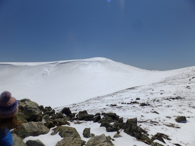
After a long ride on the chair (with a cheap family pass) we walked/skiied the 6k trail to the summit of Kosciuszko (pictured)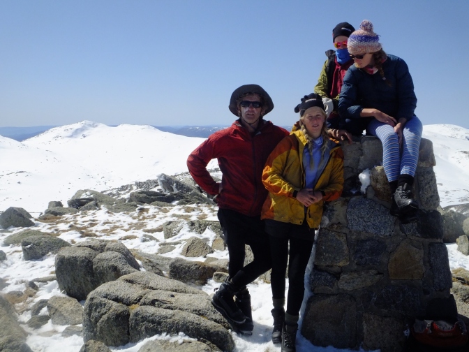
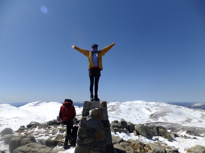 – which must be the worlds flattest looking high point! We had lunch on top of the mountain and took the obligatory group photo, in fine weather with little wind. Our first real downhill was down the North ridge
 and we all discovered that we had actually forgotten how to ski! The kids had never skied with packs on which didn’t help. At 4pm (5 hours after setting off) we were at Meuller’s pass for dinner on the grass with the new toy, a Jet Boil.
The SNOW quality was very good. It had snowed recently and it was not mushy, or icy, just glorious light and easy to ski. BUT the cover was actually poor for this time of year as it had not been a good winter in general. In a normal year there would be less grass exposed at 2000m, but there was enough snow for us sandgropers :).

Day Two
Breakfast was many badly made pancakes and some oats still in our seeping bags. At 9am we set off on the exposed traverse of the flank of Northcote, around past Club Lake to Blue Lake which was still absolutely breathtaking. We got to see some crazy back-country snow boarders skiing between the rocks on ?50 degree slopes. By lunchtime the wind was up to 50kph from the North so for our return I we discussed dropping down into the Valley of Lake Albina. The way down looked steep but the snow cover looked much better and I really wanted to get out of the wind – we were all cold with all our clothes on, and it was getting stronger.
 So we did, and it worked! We enjoyed a long downhill on good snow, out of the wind, and then an easy uphill back to our camp. We had planned to camp in the same place but I was worried about the tent holding up to the wind, so about 3pm we broke camp to head down

 to the Snowy River. We met a couple on the trail who knew the area very well and suggested we stay in Seamans Hut and also suggested a return route on the other side of Etheridge to have more snow/fun than on our ski/walk on day one – thanks whoever you were. We got a great fire going in the hut. The wind outside did get dangerously strong, so I felt justified in using the ’emergency’ shelter hut. I just wish there had been an axe so I could have replaced the kindling we used. We had a great evening ski on the gentle slope outside the hut, and made a snowman model
  of Alfie as he wasn’t with us, and it was his birthday! We stood on a rock and took our gloves off to call him, but he didn’t say much!
Day Three.
After sleeping in until 8am we eventually got going on the suggested route South of Etheridge. We traversed steeply for a while and then, into great open, fast, snow covered terrain – easily the best snow of the trip, and we had remembered how to ski by now 🙂 . The weather was amazing, and I will remember this day as one of my best ski-touring days ever! After an hour or two we rejoined the metal walkway, and skipped back to ‘civilization’. Happily the Australian high country lived up to my expectations – not as ruggard or dangerous as Canada, but beautiful in its unique way, and a lot more ‘user friendly’ It feels more like white coloured bushwalking on fast-forward than mountain skiing. The terrain draws you in and makes you feel like you can go wherever you want, its like a giant playground!
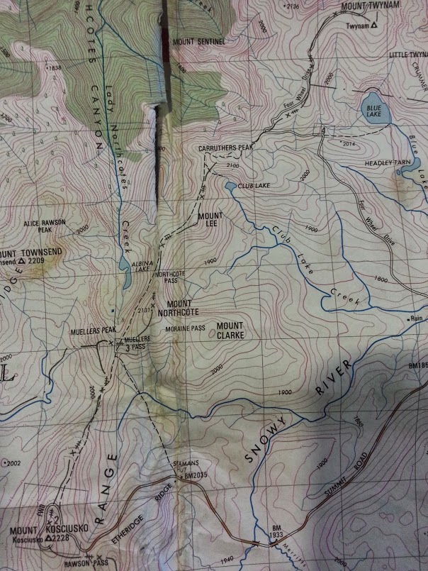
This is a photo of the interesting parts of our route (from Ed’s map which we borrowed – cheers).
Posted in Travel | 1 Comment »
Nice pic of Tarky doing Dwellingup 40km race
Posted by robjwall on September 10, 2013
Posted in Uncategorized | Leave a Comment »
Aircraft Locations!
Posted by robjwall on September 3, 2013
Its all based on volunteers receiving ADS data from the aircraft transponders.
Posted in Uncategorized | 2 Comments »
Kira is finalist in another Art Competition
Posted by robjwall on August 19, 2013
Click Here for more information

Posted in Uncategorized | 1 Comment »

You must be logged in to post a comment.