Albany Sea Kayak
Posted by robjwall on January 29, 2018
Albany Sea Kayak. Jan 26 to 28 2018.
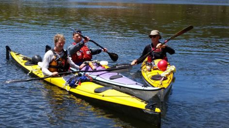
Rob, Indi, Bryan.
Day One (click for map – then choose google on down arrow bottom right, then satellite on top left)
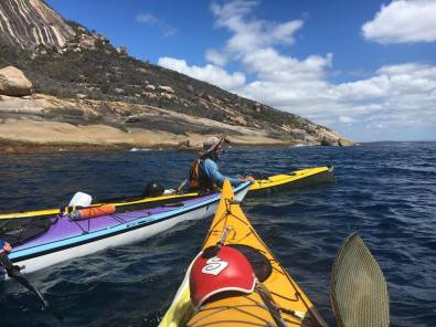
We left Emu Point at 9am after staying in the Caravan Park which was annoyingly almost but not quite at the put-in (we should have just slept on the beach). This day had the best weather forecast of our planned 3 day trip to Waychinicup, and it turned out to be perfect paddling weather — calm and warm, but not hot. We had thought to start at the whaling station, but transport logistics made it easier to start at Emu Point, so we paddled across Frenchman’s Bay past a tiny island (“Seal Island”) for a very short rest, then to the northern end of Flinder’s Peninsula. (I think there are or will be 2 or 3 really good looking Trad climbs here that I am keen to check out another time). The next leg was to Michaelmas Island where we paddled along the rocky seaward shore, very aware that this would not be so friendly most of the time. Today we saw lots of the most wonderful large grey sea-birds with very slender wings. They would swoop and glide along the sea surface coming very close to us. I am pretty sure I have seen them before, but not in such large numbers, and I don’t know what they are called. This was definitely a highlight for me!
The amazing sleeping rock
There was nowhere to land a kayak on the south side so we rested on the leeward (northern) side for a bit and had a swim from the boat. The last leg was across to a very small east facing beach on the mainland at the western end of Nanarup beach where we had a decent sized lunch. We contemplated the long crossing of this beach to take advantage of the good weather, but thought it was better not to overdo it on the first day although we all felt pretty good after about 25km of paddling in just over 3 hours. I slept under this amazing rock in case it rained, but insects were a problem! I also had some fun making a barrier to the waves like I used to when I was ten.
The forecast was for 25 knot S to SW winds by noon so we got our shit together and were paddling by 745. On the first 12k crossing the wind picked up to 20 knots or so and was an almost tail wind. This made it pretty easy going, but I found it hard to keep directional control at times. It would have been hard (impossible?) to going into the wind. We stopped briefly in the shelter of a cool rocky island with *amazing* cliff jumping potential (Tarky), and then scurried for the shelter of the headland, where the wind continued to be extremely gusty varying from nothing at all to 25 kts. We stopped at the first beach we could which is apparently called “Waterfall Beach” and setup camp just as it started raining.

Waterfall Beach
Another amazingly beautiful un-spoilt campsite with clear warmish water, perfect white sand and rocks to cook on. Paddling in it was disappointing to see a large resort building – jarring in this otherwise remote feeling location – but at least it was out of sight of our camp. A bit of napping was needed after a quite tiring paddle. 22km, 4:15 in the boats.
The forecast was for lighter winds, but an increasing swell 3m). After a later start, we made the crossing to the east end of the 2nd beach we could see (I think its called Betty’s beach). We elected not to stop, but continued following the stunning rocky coastline east for 8km. The swell was definitely moving us up and down by now, so we stayed a couple of hundred metres off the rocks (the others maybe more, as they are less obsessed with rock viewing). Of course we have no photos of the bigger seas! The large granite dome (that I climbed with Demelza in 2011) was a really useful clear landmark to head for as I knew it was 1 or 3km from Waychinicup inlet. It was slightly scary approaching the inlet as I expected to see “Monster Rock” and other familiar landmarks on the left, but they didn’t come into view for a very long time. What we did see was breaking waves over lots of other nasty rocks! I had to remind myself that I had paddled in out out of the inlet many times, and it worse conditions, and it was never a problem. Eventually I spotted Monster and Whale rocks and it was an in fact an easy paddle along some nice unbroken waves.
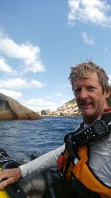
Whale Rock and the final logging off
I sheltered behind Whale rock, logged off on the VHF and practised a tired roll (don’t ask) and re-entering a flooded cockpit (better!). Finally it was a very quick (compared to the ‘red boat’ trips) paddle up to the boat ramp after 17km and 2:40 in the boat.
Gear.
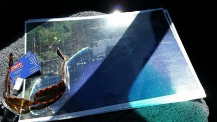
Printed Satellite photos
For navigation we used Suunto Ambit GPS watches and a set of three laminated A3 printouts from Google Earth arial photos with Long/Lat grid overlaid. These are excellent, as you can see the sand and rock clearly. Having the map grid, and a GPS watch using the same coordinate system worked really well. Also, I think that the images are probably all taken at the same time, so its valid to compare the relative size of the waves on the various beaches. But never had to do a true surf landing on this trip!
For comms we used icom M25 Marine VHF radios. My battery lasted all 3 days easily, and the mod to my PFD to clip it on was perfect. We logged on and off each day using Albany Sea Rescue who have repeaters at two locations on Chanel 82 to the west, and 81 to the east. They had trouble hearing us a lot of the time, but we were always able to log on and off after a couple of tries. I think the final message was as simple as “kayaks….. safe…. Waychinicup”. These guys do a great job, and it makes the whole thing feel a lot safer.
I paddled by Lettman Speedliner, which is great for carrying a lot of gear but doesn’t’ really handle ocean conditions very well. The others were in Raider sea kayaks. My new 225cm crankshaft carbon AT paddle was great, and I had none of the wrist problems I have had in the past. Thankfully my ‘surgery’ to shorten the paddle by 5cm and re-glue the collar was successful.
We had no issues with any of our other gear. I wish I had remembered to take a foam pad to sit on.
Conclusion.
This is a really worthwhile section of coast to Sea-Kayak, and probably doable in most weather as the landings are quite protected. That said we had SW winds, but SE or E is more common this time of year.
The ocean, the rock, the beaches, and the wildlife are all stunning, and although close to Albany you don’t feel it. I only found two pieces of litter the entire trip. I would like to do more to the east and west of here, but am less confident about finding protected beaches to land on…
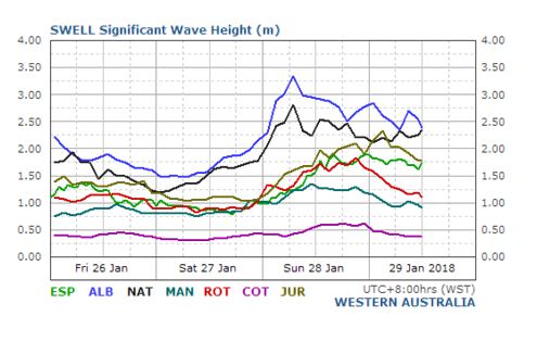
Actual Swell at ALB
Finally thanks to the many people who helped us make this trip happen in one way or another.

robjwall said
https://en.wikipedia.org/wiki/Sooty_shearwater could have been the birds we saw